Piedmont (plateau)
Plateau region between the Atlantic Plain and Blue Ridge Mountains.

Stephen sharma at English Wikipedia · Public domain
The Piedmont is a plateau region in the Eastern United States, situated between the Atlantic Plain and the Blue Ridge Mountains. It stretches from New Jersey in the north to central Alabama in the south and is a physiographic province of the larger Appalachian Highlands division.
- location
- Eastern United States, from New Jersey to central Alabama
- ecoregion
- Piedmont ecoregion (45) designated by EPA; CEC uses a different numbering system
Lore & Background
The Piedmont's geology is complex, with rock formations from at least five separate sediment deposition events, including the Grenville orogeny and the Appalachian orogeny. The last major event was the break-up of Pangaea, which created Mesozoic basins largely located within the Piedmont. Its surface relief features relatively low, rolling hills. The Piedmont ecoregion is a transitional area between the Appalachian mountains and the coastal plain, with a mosaic of metamorphic and igneous rocks. Once largely cultivated, much of the region has reverted to successional pine and hardwood woodlands, with increasing urban and suburban land cover. Soils are generally clay-like and moderately productive, though some areas have suffered from erosion and over-cropping. The portion of the Piedmont in the Southern United States is associated with the Piedmont blues, a style that originated there in the late 19th century. During the Great Migration, African Americans migrated to the Piedmont, and the region's music was influenced by ragtime, country, and popular songs.
Reader's Guide
The Piedmont plateau is significant as a major physiographic province of the Appalachian Highlands, spanning multiple states and containing numerous major cities along the Atlantic Seaboard Fall Line. Its geology records ancient mountain-building events and the break-up of Pangaea, providing insight into Earth's tectonic history. The region's ecology represents a transitional zone between mountains and coastal plain, with distinctive soils and land cover changes from agriculture to urban development. Culturally, the Piedmont is notable as the birthplace of Piedmont blues, a musical style shaped by the region's demographic patterns during the Great Migration. The fall line cities, including Atlanta, Baltimore–Washington, Richmond, Charlotte, and Philadelphia, highlight the Piedmont's role as a corridor for settlement and commerce. The region's agricultural history, particularly tobacco in the central Piedmont and cotton in the South, has shaped its economic and social development.
Did You Know?
- The French word 'Piedmont' comes from Italian 'Piemonte,' from Latin 'pedemontium,' meaning 'foothill' or 'at the foot of the mountains.'
- The Piedmont's width varies from narrow above the Delaware River to nearly 300 miles (500 km) wide in North Carolina.
- The Atlantic Seaboard Fall Line marks the Piedmont's eastern boundary with the Coastal Plain and is where many major cities are located.
- The Piedmont blues style originated in the late 19th century and was influenced by ragtime, country, and popular songs.
Defining the Piedmont Form
A piedmont plateau occupies a distinctive geographic position, sitting as a transitional zone between two contrasting landscapes. By definition, a plateau is an elevated area of relatively flat terrain that rises sharply above its surroundings on at least one side, often flanked by deep escarpments or rolling hills. The piedmont variety is specifically characterized by being bordered on one side by a mountain range and on the other by a lowland plain or a sea. This in-between placement gives piedmont plateaus a unique topographic identity distinct from both the rugged peaks behind them and the gentle flats ahead of them. Like all plateaus, they can range from having a narrow, compact flat top to stretching across a broad, expansive surface. The term itself, derived from the French plateau, simply means a flat elevated area, but the piedmont modifier pins down exactly where in the landscape that flatness sits relative to mountains and plains.
How the Land Rises
The elevated flatness of a piedmont plateau is not the product of a single geological event but rather the result of powerful forces acting over immense spans of time. Several mechanisms can produce these landforms. Volcanic activity plays a role when magma wells up from the mantle, swelling the ground upward into broad, level surfaces, or when lava extrudes from cracks in the crust and spreads outward, building up layered rock. Tectonic plate movements can also drive uplift, creating large, uniformly elevated areas. Erosion by water and glaciers carves down surrounding mountain ranges, leaving the more resistant interior standing as a flat-topped remnant. In some cases, rivers dissect these surfaces over millions of years, cutting deep narrow valleys through what was once a continuous plain. The interplay of uplift and erosion means that a piedmont plateau's final shape reflects a long negotiation between forces that build the land up and forces that wear it down.
A Place Between Worlds
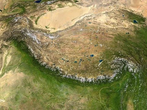
Geologists classify plateaus according to their surrounding environment, and the piedmont type occupies a middle ground in this scheme. Intermontane plateaus, such as the Tibetan Plateau sandwiched between the Himalayas and the Kunlun Mountains, or the Altiplano nestled between two Andean ranges, are fully enclosed by fold mountains and tend to be among the highest and most extensive on Earth. Continental plateaus, like the Antarctic Plateau in East Antarctica, are surrounded on all sides by plains or oceans, forming far from any mountain chain. Piedmont plateaus fall between these two extremes: they share a boundary with mountains on one side but open onto a plain or sea on the other. This partial enclosure gives them a transitional character, neither fully locked in a mountain basin nor fully exposed to open lowland, making them a bridge between the most dramatic and the most open of plateau settings.
The Eastern American Example
The most frequently cited example of a piedmont plateau is the Piedmont Plateau in the Eastern United States. It stretches between the Appalachian Mountains to the west and the Atlantic Plain to the east, perfectly illustrating the defining criterion of the piedmont type: mountains on one side, a lowland plain on the other. This positioning gives the region a character shaped by transition, where the rugged terrain of the Appalachians gradually gives way to the flatter coastal lowlands. The plateau's surface, like others of its kind, may show evidence of the various geological processes that created it, from ancient volcanic or tectonic uplift to the persistent work of water erosion. Its escarpments and hills mark the boundary where the elevated flat terrain meets the lower plain, creating the sharp rise that distinguishes a plateau from the surrounding landscape. The region stands as a textbook case of how a single landform type can define an entire geographic identity.
Gallery

Frequently Asked Questions
Who is Piedmont (plateau)?
The Piedmont is a plateau province in the Eastern United States, tucked between the Atlantic Plain to the east and the Blue Ridge Mountains to the west. It is officially recognized as a physiographic province within the broader Appalachian Highlands division.
What are Piedmont (plateau)'s powers/role?
The Piedmont acts as a transitional landform, linking the low coastal plain to the higher Appalachian terrain and creating its own distinct ecoregion (EPA number 45). Its unique geology and soils support ecological communities that differ from both neighboring provinces.
How does Piedmont (plateau)'s story end?
The plateau's southern terminus falls in central Alabama, where the landform effectively concludes. Its northern starting point is New Jersey, giving it a long north-to-south arc hugging the eastern seaboard.
Why is Piedmont (plateau) important?
It occupies a critical corridor between two major physiographic provinces, shaping drainage patterns, climate gradients, and settlement history across the Eastern U.S. Its position makes it a defining subdivision of the Appalachian Highlands.
Where is Piedmont (plateau)'s home base?
The plateau runs from New Jersey in the north to central Alabama in the south, always sitting between the Atlantic Plain and the Blue Ridge. It is sometimes catalogued under a different numbering scheme by the Council on Environmental Quality, though the EPA assigns it ecoregion 45.
More in Plateaus And Plains 25-27
Elsewhere in the Plateaus And Plains universe
Spotted an error? Know more?
This is a living reference — every entry is fact-audited, and reader corrections feed straight into our audit queue. Suggest an edit · See this site's audit record