Colorado Plateau
A high plateau bisected by the Grand Canyon.

via Wikipedia: Plateau · see source
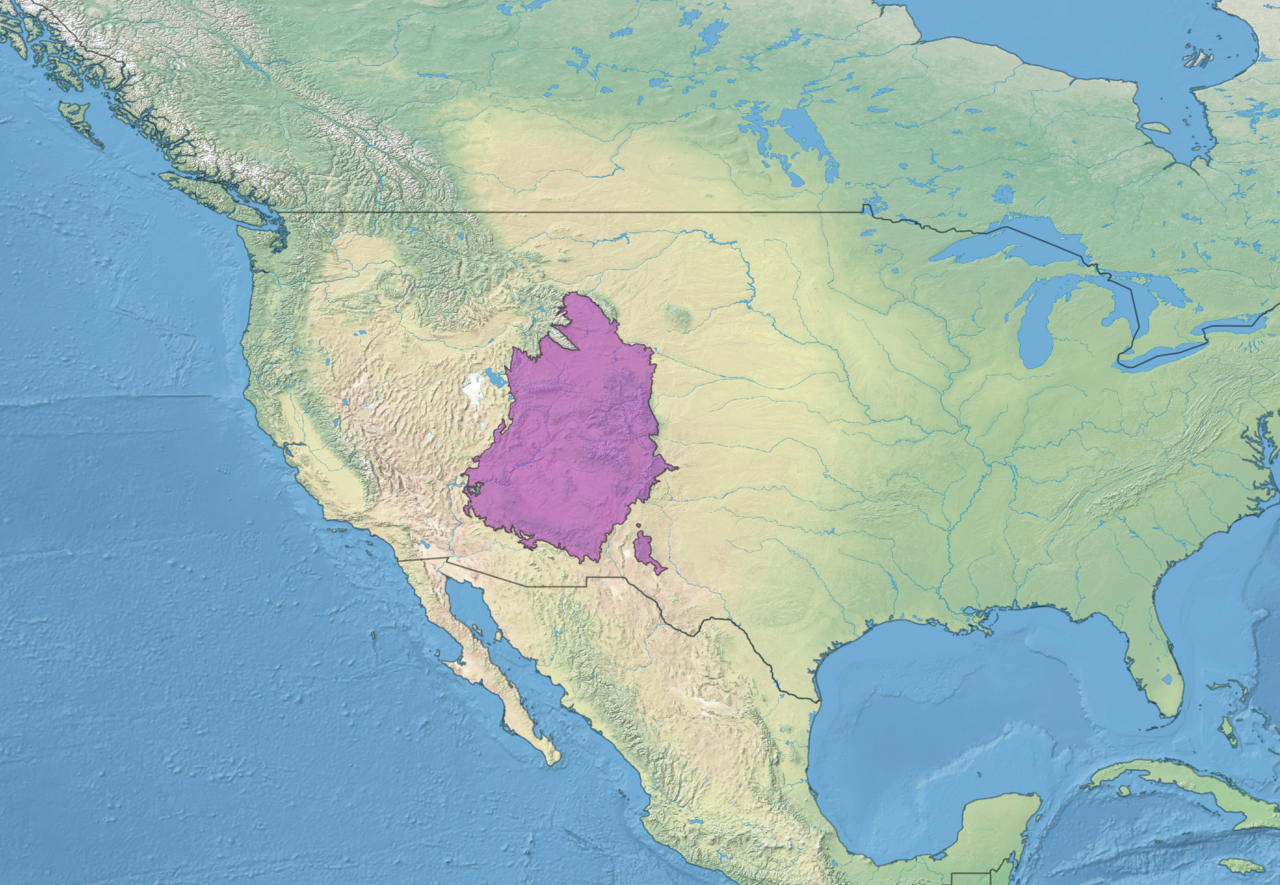
The Colorado Plateau is a large plateau in North America that covers about 337,000 km² (130,000 sq mi) in Colorado, Arizona, New Mexico, and Utah. In northern Arizona and southern Utah, the plateau is bisected by the Grand Canyon of the Colorado River. The North Rim of the Grand Canyon is at an elevation of about 2,450 m (8,040 ft) above sea level, and the South Rim is about 2,150 m (7,050 ft) above sea level. At its deepest, the Colorado River is about 1,830 m (6,000 ft) below the level of the North Rim.
- area
- 130,000 sq mi (340,000 km2)
- location
- Four Corners region of the Southwestern United States
Lore & Background
The Colorado Plateau covers about 337,000 km² (130,000 sq mi) in Colorado, Arizona, New Mexico, and Utah. In northern Arizona and southern Utah, the Colorado Plateau is bisected by the Grand Canyon of the Colorado River. This came to be over 10 million years ago - the river was already there, though not necessarily on exactly the same course. Then, subterranean geological forces caused the land in that part of North America to gradually rise by about a centimeter per year for millions of years. An unusual balance occurred: the river that would become the Colorado River was able to erode into the crust of the Earth at a nearly equal rate to the uplift of the plateau. Now, millions of years later, the North Rim of the Grand Canyon is at an elevation of about 2,450 m (8,040 ft) above sea level, and the South Rim of the Grand Canyon is about 2,150 m (7,050 ft) above sea level. At its deepest, the Colorado River is about 1,830 m (6,000 ft) below the level of the North Rim.
Reader's Guide
The Colorado Plateau covers about 337,000 km² (130,000 sq mi) in Colorado, Arizona, New Mexico, and Utah. In northern Arizona and southern Utah, the Colorado Plateau is bisected by the Grand Canyon of the Colorado River. This came to be over 10 million years ago - the river was already there, though not necessarily on exactly the same course. Then, subterranean geological forces caused the land in that part of North America to gradually rise by about a centimeter per year for millions of years. An unusual balance occurred: the river that would become the Colorado River was able to erode into the crust of the Earth at a nearly equal rate to the uplift of the plateau. Now, millions of years later, the North Rim of the Grand Canyon is at an elevation of about 2,450 m (8,040 ft) above sea level, and the South Rim of the Grand Canyon is about 2,150 m (7,050 ft) above sea level. At its deepest, the Colorado River is about 1,830 m (6,000 ft) below the level of the North Rim.
Did You Know?
- The Colorado Plateau covers about 337,000 km² (130,000 sq mi) in Colorado, Arizona, New Mexico, and Utah.
- The Grand Canyon bisects the Colorado Plateau in northern Arizona and southern Utah.
- The North Rim of the Grand Canyon is at an elevation of about 2,450 m (8,040 ft) above sea level.
- The South Rim of the Grand Canyon is about 2,150 m (7,050 ft) above sea level.
- At its deepest, the Colorado River is about 1,830 m (6,000 ft) below the level of the North Rim.
Scale and Geographic Reach
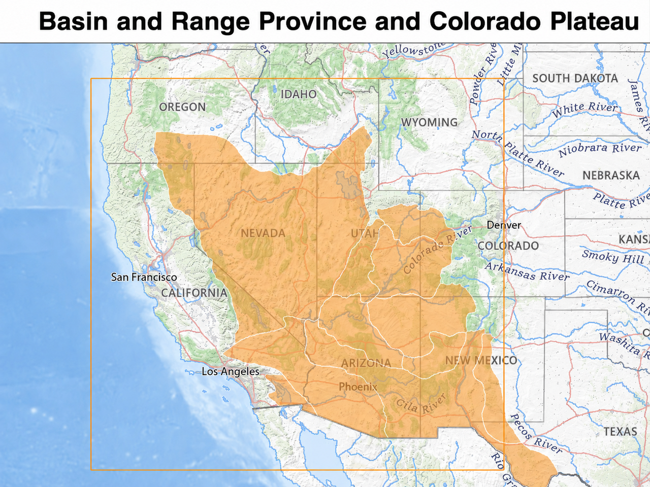
The Colorado Plateau covers about 337,000 km² (130,000 sq mi) in Colorado, Arizona, New Mexico, and Utah. In northern Arizona and southern Utah, the Colorado Plateau is bisected by the Grand Canyon of the Colorado River.
The Grand Canyon: A Story of Balanced Forces
In northern Arizona and southern Utah, the Colorado Plateau is bisected by the Grand Canyon of the Colorado River. This came to be over 10 million years ago - the river was already there, though not necessarily on exactly the same course. Then, subterranean geological forces caused the land in that part of North America to gradually rise by about a centimeter per year for millions of years. An unusual balance occurred: the river that would become the Colorado River was able to erode into the crust of the Earth at a nearly equal rate to the uplift of the plateau. Now, millions of years later, the North Rim of the Grand Canyon is at an elevation of about 2,450 m (8,040 ft) above sea level, and the South Rim of the Grand Canyon is about 2,150 m (7,050 ft) above sea level. At its deepest, the Colorado River is about 1,830 m (6,000 ft) below the level of the North Rim.
Tectonic Origins and Slow Uplift
Subterranean geological forces caused the land in that part of North America to gradually rise by about a centimeter per year for millions of years. The river that would become the Colorado River was able to erode into the crust of the Earth at a nearly equal rate to the uplift of the plateau.
A Dissected Landscape
The Colorado Plateau is bisected by the Grand Canyon of the Colorado River. The river was able to erode into the crust of the Earth at a nearly equal rate to the uplift of the plateau. The North Rim of the Grand Canyon is at an elevation of about 2,450 m (8,040 ft) above sea level, and the South Rim of the Grand Canyon is about 2,150 m (7,050 ft) above sea level. At its deepest, the Colorado River is about 1,830 m (6,000 ft) below the level of the North Rim.
Gallery
Frequently Asked Questions
Who is Colorado Plateau?
Colorado Plateau is a massive elevated landform spanning roughly 337,000 square kilometres across the Four Corners region of the Southwestern United States. It stretches through parts of Colorado, Arizona, New Mexico, and Utah, making it one of the largest continuous high-elevation surfaces in North America.
What is Colorado Plateau's role in the series?
It serves as the central stage for the Colorado River's Grand Canyon, which slices through its interior in northern Arizona and southern Utah. The plateau essentially frames the canyon, with its rim sitting around 2,450 metres above sea level on the north side and roughly 2,150 metres on the south side.
Where does Colorado Plateau appear on the map?
Its territory covers the Four Corners area, touching all four states that meet at that geographic point. The Grand Canyon, its most iconic feature, cuts across the boundary between northern Arizona and southern Utah.
How does Colorado Plateau's story end?
It does not end in any narrative sense; the plateau persists as a stable, long-lived geological structure that has endured for millions of years. Its ongoing 'arc' is the slow, continuous deepening of the Colorado River's canyon, which at its deepest point drops about 1,830 metres below the North Rim.
Why is Colorado Plateau important to fans of the series?
Its sheer scale—over 130,000 square miles of elevated terrain—gives it a dominant presence that anchors the entire Southwestern landscape. The dramatic elevation difference between its rim and the river floor creates the visual spectacle that defines the Grand Canyon and draws countless visitors and storytellers.
More in Plateaus And Plains 1-24
Related in Plateaus And Plains
Links follow this subject's own source article.
Elsewhere in the Plateaus And Plains universe
Spotted an error? Know more?
This is a living reference — every entry is fact-audited, and reader corrections feed straight into our audit queue. Suggest an edit · See this site's audit record